Projetcs
Welcome to Our Geotechnical Science and Numerical Modeling Showcase
Explore the heart of our work in geotechnical science and numerical modeling. Our portfolio highlights the innovative projects we’ve undertaken to solve complex geological challenges. Each project represents a step forward in understanding and manipulating the earth’s subsurface environment, blending cutting-edge numerical models with practical engineering solutions.
Dive into detailed descriptions, high-quality images, and insights into the methodologies that drive our success. Witness how we turn theoretical concepts into tangible results, ensuring stability and safety in diverse environmental conditions. Join us on this journey as we push the boundaries of geotechnical engineering and numerical analysis.
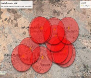
Impact of Subsurface Water Level Reduction on Kerman's Consolidation Settlement
levels of the subsurface water are a problem with a confident engineering perspective with consideration of geotechnical environments with coarse-grained soils and rocks. The reduced level of water is the factor of destruction because with the earthquakes, the degree of liquefaction of the soil layers, which by reducing its level, the problem will be solved. But the problem in the environment of Kerman city is very different, because the soil of Kerman is completely finegrained and, of course, collapsible, but when the collapsible soil with the potential of subsidence is faced with a water problem, it will have instant porosity and destruction and the initiation of deep cracks. But in Kerman, due to the presence of the subsurface water layer for a long time, the clay has a structure and of course a suitable compromise, but due to the decrease of the subsurface water level and the outflow of water from the Kerman clay particles, this soil has regained its collapsible origin and in Now it is reacting to it, and due to the presence of static loads on the structure, the cause of deep cracks and many settlements of the city surface shows itself well. Another point in the context of Kerman city is, its classification under the title of zoning with high relative risk, where an earthquake coefficient greater than 0.35 seismic acceleration is applied in the calculations, but when the settlements of Kerman city, which is an earthquake-prone region, are involved in the process Consolidation and longterm destructive factors do not threaten the city and its civil infrastructure, but when the immediate settlements and consolidation and the weakness of the collapsing clay of Kerman are placed next to the earthquake problem, it causes the geotechnical system to have a destructive and rupture process. It is very important to determine the degree of destruction of these two physical and mechanical factors of the soil structure and to provide an accurate prediction of the speed of its progress at the level of Kerman city with an accurate view of the interaction between the soil and the structure.
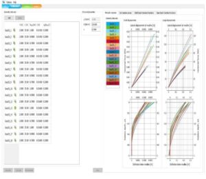
Methanol Export Terminal
Qeshm Oil Investment Company [hereafter the Company] of Tehran, Iran, have contracted Horizon Geotechnical Company [hereafter HGC], a subsidiary of Horizon Survey Company FZC, of Sharjah, U.A.E., to carry out an offshore survey and geotechnical investigation in support of the Bandar Abbas Crude Oil Supply Project. The Company has contracted Moeen Energy Paya Company (MEP) to manage the project and Daraya Pala Engineering Company (DP) as consultant for this project.
The site of the geotechnical work is located in the Persian Gulf at two locations:
a. South West of Qeshm Island, 4.08 km from the south coast opposite Messen town in 49.2 m water depth for a proposed Single Point Mooring (SPM), Pipeline End Manifold (PLEM), and associated 4.08 km subsea pipeline.
b. The Khuran Strait between the north of Qeshm Island and Bandar Abbas Refinery for a proposed 10 km subsea pipeline.
The original scope of work for the geotechnical investigation at the SPM1 site, SW of Qeshm Island, was to perform one (1) borehole to a minimum depth of 50 m below seabed at the center of the PLEM location and three (3) boreholes to a minimum depth of 50 m below seabed at each of the anchor pile locations, PILE-1, PILE-3, and PILE-5. The scope of work was increased to include an additional PLEM and three anchor pile locations at the SPM2 site, together with boreholes along the associated SPM2 pipeline route.
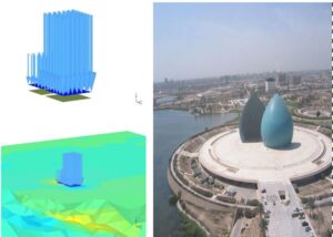
Interference of Raft Foundations on Clay: Baghdad University Study
In recent years, the study of closely spaced footings plays a vital practical consideration in geotechnical and structural engineering, as growing urbanization and land constraints have pushed structures ever closer together, resulting in frequent interference between closely spaced foundations. As a result, the failure mechanism changes, resulting in a change in the bearing capacity as well as settlement-related problems associated with overlapping footings. The soil structure interaction effect is often determined by parameters such as footing spacing, applied load intensity, a soil characteristics. This effect will vary depending on the soil type. Density, cohesiveness, and angle of internal friction are factors that contribute to the interaction effect. The existence of clayey soil deposit on the construction site may add to the ambiguity of this issue, since there is no consensus among researchers addressing the interference of footing behavior on clay bed, in contrast to sand. Importance of the interaction effect of shallow foundations was first noticed by Stuart . Experimental and limit state method were used and an equation proposed for calculating bearing capacity with the interference effect by the inclusion of efficiency factors. Das and Larbi-Cherif. compared the model study results with previous studies and found out that efficiency factor magnitudes are lower when S/B less than 3. Graham and his colleague considered three parallel strip footings and calculated efficiency factor as the ratio of failure load of the central interfering footing to the capacity of a similar isolated footing. Efficiencies are highest at close spacing and decreases until the footings act as independently. Kumar and his team studied the interaction of footings resting on reinforced earth slab. In this study, he found that in case of interfering footings resting on reinforced soil, the magnitude of settlement and tilt decreases for a given load intensity as compared to the same footings on unreinforced soil for the same load intensity. So in our countribution in to this project the IGFS completely accept the nuerical study and analyzin g the result of each acpect of this project and our collaboration with baghdad university were completely insightful.
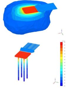
Influence of Soil Models on FEM Geotechnical Simulation: Dresden University Collaboration
The finite element method (FEM) is suitable for verifying the loadbearing capacity and serviceability of foundations. In practice, the program system Plaxis 2D or 3D is very often used, which offers the possibility to consider different material models for the simulation of the soil behavior. In practical applications, soil behavior is very often simulated with a simple Mohr-Coulomb (MC) , which, however, cannot represent the highly nonlinear and anelastic behavior of the soil. Higher-order fabric models, such as hypoplasticity, which take into account the influences of barotropy and pycnotropy, among others, are rarely used in practice due to their complexity. In this thesis, the influences of simple and higher order material models on the load-deformation behavior of foundation systems will be investigated. Drained soil conditions shall be assumed and inclined loads shall be considered. The investigations shall be limited to sandy soils and the material models Mohr-Coulomb, Hardening Soil, Hardening-Soil-SmallStrain and Hypoplasticity with Intergranular Strain shall be applied.
Specifically, IGFS Contribution were the following items which are to be addressed:
1. Literature study on the mentioned substance models. The application limits of the material models under static load are to be shown. In addition, the calibration of the material parameters should be described in detail, for example by means of laboratory tests or by means of correlations from the literature.
2. Creation of numerical models for shallow foundations and deep foundations, each with two different model soils in Plaxis 3D. The material parameters are either taken from the literature or calibrated with the Plaxis SalTest-Tool based on laboratory data. In addition to the load H/V, the foundation dimensions are to be varied for shallow foundations and the pile axis spacing, pile diameters and pile lengths are to be varied for deep foundations. Furthermore, the piles of the deep foundation are to be modeled with volume elements as well as with embedded beams. A detailed investigation program is to be worked out and coordinated with the project supervisor.
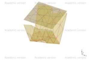
Ultimate Bearing Capacity of Layered Soil: Plaxis 3D Study Collaboration
Observed all the data i.e. soil properties need for the thesis including modulus of elasticity, poison ratio, unit weight of soil, cohesion and angle of shear resistance. Started solving various problems that will back up with the major problem. Getting familiar with Plaxis 3d and analyzing all the data in the software.
OBJECTIVES IDENTIFIED: – The objective of this study are:
1. To evaluate the bearing capacity of layered soils using finite element analysis Based software.
2. To compare the results of evaluation of bearing capacity of layered soils using PLAXIS 3D and those from other theories based on foundation type, geometry, soil type and different loading.
3. To conduct parametric studies.
LITERATURE SURVEY: – All the literature survey has completed. WORK PLAN: –
1. Gathering the data of the soil of a commercial complex at plot no. 88, Rudapur and analyzing the shallow foundation with layered soil while considering ground water table.
2. Creating a geometric model of the observed data using Plaxis 3D and conducting preliminary checks to ensure the accuracy of model used in numerical analysis.
3. Generating model and plotting pressure-settlement curve using Plaxis 3D. Calculating the bearing capacity of the soil using empirical method and comparing it with the result from Plaxis 3D.
MODELING:
Introduction- In this section of the research, soils are modeled with adjacent foundation loads with different foundation types in which the details will be discussed in the subsequent sections. It has been taken one type of load for isolated type of foundation load and for the given load one to four types of soil layers were considered. The depth is 6m for all the cases. There are cases in which the two layers are positioned. That is silty sand and clayey silt.In the analysis it is tried to analyze the difference and also the similarity between conventional methods which has been known for many years by Geotechnical Engineers and also FEM which has gain much acceptance in recent years. From the result it has shown that the bearing capacity calculation for FEM is higher than conventional methods in many cases. Since FEM has taken into account approximate solutions it analyzed the soil condition and gives higher values than that of conventional method which takes the soil as a homogenous and isotropic even though the real soil condition is not like that, most of the time.
